 |
Weaverville
is a gold rush town surrounded by the forested mountains in what is known as the Trinity Alp Wilderness of northern California. This small town, which is approximately 45 minutes from Redding, is the county seat and sits on the banks of Trinity River near Shasta Lake. Weaverville's great location makes for fantastic outdoors recreation such as day hikes, camping, rafting, swimming, rock climbing, cycling and more. Fishing in the mountain lakes and streams of Trinity County is fantastic! For a different kind of experience, there is still gold to be found in Trinity County, and gold panning is allowed on public federal lands. Weaverville is a town of historical interest and places to visit include the Joss House, the Old Stamp Mill, the Jackson Museum, as well as several local specialty shops and art galleries. There are plenty of hotels and restaurants in Trinity County, where you can enjoy everything from barbecue to a good burger. Weaverville in Trinity County is a quiet, beautiful vacation destination in one of the most pristine and unspoiled regions of the country.
Surrounding areas: Douglas City, California (5.8 mi), Trinity Center, California (21.1 mi), Coffee Creek, California (27.1 mi), Hyampom, California (28.2 mi), Shasta Lake, California (29.9 mi), Redding, California (31.7 mi), Hawkins Bar, California (32.0 mi)
|

|
Weaverville Vacation Rentals
|

|
|
|
|
|
Weaverville Hotels and Resorts
|
|
|
| | | Hotels & Motels |
| Red Hill Motel | | Weaverville, CA | | (530) 623-4331 | | Weaverville Victorian Inn | 1709 Main St 299W | Weaverville, CA | | (530) 623-4432 | | Lewiston Valley Motel | | Lewiston, CA | 7.1 mi. | (530) 778-3942 |

|
Weaverville Weather & Climate
|

|
|
|
The climate in the Shasta-Trinity National Forest region varies greatly with elevation. Located in North-Central California, the National Forest covers over two million acres. Higher elevations tend to have much cooler temperatures and higher precipitation. Summer weather is usually hot and dry in the lower elevations, with temperatures ranging from 85 degrees - 100 degrees and lows from 60- 70 degrees. Fall days are usually mild and warm, with cool nights. Winter is when most of the precipitation falls, averaging over 55 inches per year, much of it in the form of snow in the high elevations. Highs range from 40 - 60 degrees and lows from 30 - 40 degrees in the lower elevations in winter. Spring weather is variable with many pleasant days and cool nights.
|
| Month |
High Temp |
Low Temp |
Rainfall |
Ocean Temp |
| January |
49°F |
27°F |
7.08 in. |
- |
| February |
54°F |
29°F |
6.05 in. |
- |
| March |
59°F |
31°F |
5.49 in. |
- |
| April |
67°F |
33°F |
2.25 in. |
- |
| May |
76°F |
39°F |
1.31 in. |
- |
| June |
85°F |
45°F |
0.58 in. |
- |
| July |
94°F |
49°F |
0.23 in. |
- |
| August |
94°F |
48°F |
0.27 in. |
- |
| September |
87°F |
42°F |
1.05 in. |
- |
| October |
75°F |
35°F |
2.34 in. |
- |
| November |
55°F |
32°F |
5.47 in. |
- |
| December |
47°F |
27°F |
6.29 in. |
- |

|
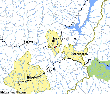
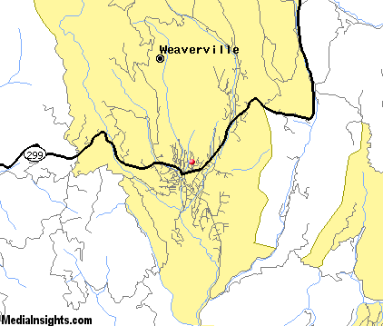
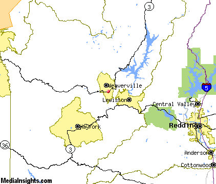
Weaverville Map & Transportation
|

|
|
 |
|
|
| Click each thumbnail image to enlarge. |
 |
|
 |
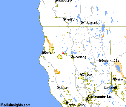 |
The closest airports in the area are the Redding Municipal airport (RDD) located about 37 miles southeast of Weaverville in Redding, California, the Red Bluff Municipal airport (RBL) located approximately 54 miles southeast of Weaverville in Red Bluff, California, the Weed airport (O46) located roughly 56 miles northeast of Weaverville in Weed, California, and finally the Arcata airport (ACV) located around 63 miles west of Weaverville in Arcata / Eureka, California.
|

|
Weaverville Attractions
|

|
|
| | | Water Parks |
| Waterworks Park | Redding | CA | 30.4 mi. | |
| | | Golf Courses |
| Trinity Alps Golf & Country Club | Weaverville | CA | | | | Lake Redding Golf Course | Redding | CA | 29.8 mi. | |
| | | Ski Areas |
| Mount Shasta Ski Park | Shasta | CA | 25.2 mi. | | | Mount Ashland | Ashland | OR | 101.4 mi. | |
| | | Museums |
| Herb Lane Museum | Redding | CA | 30.4 mi. | (Art) | | Redding Museum of Art and History | Redding | CA | 30.4 mi. | (Art) |
| | | Zoos and Aquariums |
| Sequoia Park Zoo | Eureka | CA | 64.3 mi. | |
Notice a problem with the information on this page? Please notify us.
|
Disclaimer: We recommend you conduct your own research regarding all accomodations and attractions found on this website. The distances shown on this website are straight-line distances as the crow flies. The road distance may be considerably longer. You assume all liability for use of any information found on this website. No information is confirmed or warranted in any way. By using our services you agree to the terms and conditions of this disclaimer.
|
| We are the #1 site for your California Vacation presenting California vacation rentals, hotels, weather and map for each city. |
California Vacation and Hawaiian Vacation are publications and trademarks of Media Insights, Inc.
©1997-2025 All Rights Reserved.
|
|